


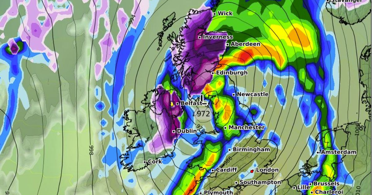
Wet and wintry weather is forecasted to sweep across the UK, with stormy conditions expected throughout the Easter weekend and into the next month. Snow could hit some parts of the UK in just a few days, as forecast maps show a large front sweeping in from the Atlantic on April 6. Parts of Scotland and Northern Ireland are forecasted to receive snowfall, with rates of up to 5cm per hour in the worst affected areas. Torrential downpours are expected in Northern England and Wales, with clearing skies towards the end of the day. The unsettled outlook for the start of next month follows a warning from forecasters of a wet Easter weekend, with damp conditions likely to persist until Monday.
Sunseekers can take advantage of a money-saving travel deal that allows them to book two holidays for the price of one. The Met Office’s outlook for the bank holiday weekend suggests that showers will continue, especially in southern and western areas. Yet, there is a possibility of improvement with showers becoming less frequent and longer spells of sunshine appearing in eastern and northern areas. Winds will also calm down, and temperatures are expected to rise, providing a warmer feel in any sunshine. While the weather may improve temporarily, unsettled conditions are likely to return by Easter Monday, although the timing of this deterioration remains uncertain. Rainy conditions are expected for much of the country on Wednesday, with heavier showers developing in Wales and the southwest later in the day.
A yellow weather warning is in place in Northern Ireland, with the Met Office cautioning that persistent rain overnight could lead to some impacts on travel and infrastructure. The forecast for Thursday to Saturday includes sunny spells alongside heavy scattered showers. Thursday is expected to be windy, while Friday and Saturday may see slightly more settled weather. The weekend brings a mix of sun and showers, with the potential for heavier rain in parts. Wednesday’s weather outlook calls for spells of rain moving north and east, with some bright spells in between and heavy, blustery showers expected in the west later in the day. Daytime temperatures are forecasted to be around 11C in the south and 9C in the north.
Given the ongoing stormy and wet conditions, the UK is bracing for potentially disruptive weather patterns. The weekend weather could bring snowfall and heavy rain to different regions, affecting travel and infrastructure. In response, there is a need for caution among residents and travelers, with preparations advised for possible disruptions due to the storm’s impact. Additionally, given the variability and unpredictability of the season, it is essential to stay informed with the latest weather updates and warnings to ensure safety and preparedness during the unsettled weather conditions. Overall, the outlook suggests a challenging period ahead, with the likelihood of continued stormy weather and unsettled conditions in the upcoming days and weeks.


