


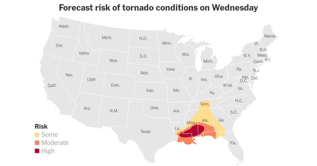
Waves of intense weather moved east on Wednesday, bringing flash flooding and tornadoes to the New Orleans area and other parts of the central Gulf Coast, according to the National Weather Service. More than a dozen flash flood warnings were issued early in the day, with one to three inches of rain possible in New Orleans, where between one-half and two inches had already fallen. The forecast included a substantial risk of tornadoes in the area, with some possibly being strong. Tornado warnings were issued for rural areas, with more expected through the morning. The Weather Service warned that more than seven million people across Louisiana, Mississippi, and Alabama could experience extreme weather throughout the day.
The deteriorating weather in the region began before dawn, with the Weather Service issuing tornado warnings and watches that covered towns from Texas to Mississippi. Flooding began to inundate areas in east Texas, with schools closed and roads shut down in the city of Kirbyville in Jasper County. The mayor of Kirbyville stated that volunteers and rescue teams were working to help stranded people, though there were no fatalities or injuries reported. The Weather Service issued a flurry of flash flood warnings, including one for the areas surrounding Jackson, Mississippi, affecting nearly 400,000 residents. Forecasters predicted that the approaching storms could dump up to four inches of rain from northeast Louisiana to southwest Georgia and the Florida panhandle, along with producing hail and high winds throughout the evening.
While the severe weather was expected to peak in the morning and run through the afternoon, parts of Mississippi were already hit by an overnight storm, with at least one tornado reported in Raymond. The National Weather Service office in New Orleans stated that the storms moving across the city would bring heavy rain and flash flooding. In anticipation of the weather, officials closed City Hall and other city buildings but schools remained open. The Weather Service office in Jackson warned residents of damaging winds up to 70 miles per hour, an increased chance of tornadoes, and hail. Residents and visitors were advised to have multiple ways to receive warnings and not to drive through flooded roadways.
The tornado warnings and watches issued in the central Gulf Coast region were part of a larger weather system affecting a vast area, with storms stretching from Texas to Mississippi and a significant risk of flooding and severe weather. The mesoscale convective system that moved through the area brought heavy rain, tornadoes, and flash flooding, prompting officials to warn residents to take precautions and stay alert for further warnings. In the midst of the storms, volunteer rescue teams were deployed to help those stranded by rising waters in Kirbyville, Texas. Despite the challenging conditions, there were no reported fatalities or injuries, with efforts focused on evacuating people to safety in the face of continued rainfall and potential flooding.
As the day progressed, the Weather Service continued to monitor the severe weather moving through the central Gulf Coast region, issuing updates on tornado warnings, flash flood warnings, and watches. Schools and city buildings remained closed in some areas as residents braced for the impact of the storms. Emergency response teams were on high alert to assist those in need, with shelters open to accommodate those displaced by flooding. The Weather Service urged residents and visitors to stay informed and avoid driving through flooded areas, emphasizing the importance of preparedness during extreme weather events. Despite the challenges posed by the severe weather, communities in the central Gulf Coast region worked together to ensure the safety and well-being of all residents in the face of the ongoing storms.


